General Information
Nahiya (Subdistrict)
Efrîn
Also Known As
Barj Haedar, Birc Ĝêderê, Burj Haider, برج حيدر
Tribes
Dinna
Families, Clans, etc.
Gula Xêrê

Photos
Basic Information about Birc Ĥêderê
Source: Tirej Afrin
Etymology: The village derived its name from an archaeological tower (burc) still standing in the center of the village, and from the name of its first inhabitant Heyder. "Burc" is a word of Greek origin.
Foundation Date/Period: Approximately 500 years ago (current village)
Hills: Çiyayê Lîlon, Simean
Other Landmarks: Wadiyê Rekiyê
Summaries
I. Summary from TirejAfrin Site (English) of Birc Ĥêderê
Source: https://www.tirejafrin.com/site/kura%20afrin%20markaz-barj%20haedar.htm
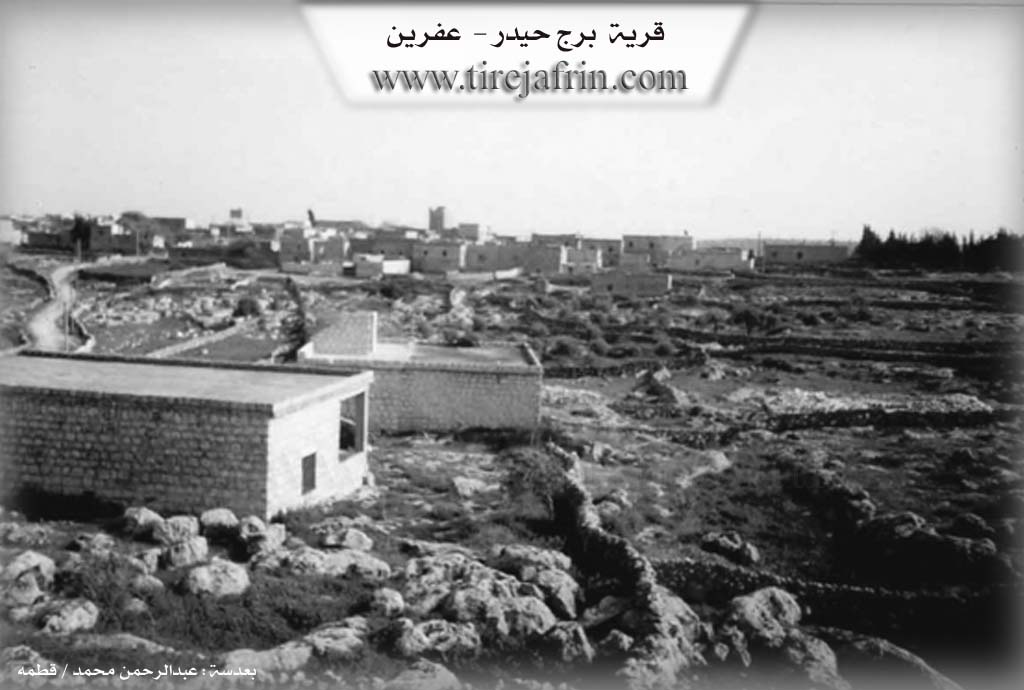
It is stated in the book جبل الكرد (عفرين) دراسة جغرافية Çiyayê Kurmênc (Efrîn): A Geographical Study by د. محمد عبدو علي Dr. Mihemed Ebdo Elî: Burc Heyder /949 inhabitants - 194 houses - 33km - 575m/:
The village derived its name from an archaeological tower (burc) still standing in the center of the village, and from the name of its first inhabitant Heyder. "Burc" is a word of Greek origin as is known.
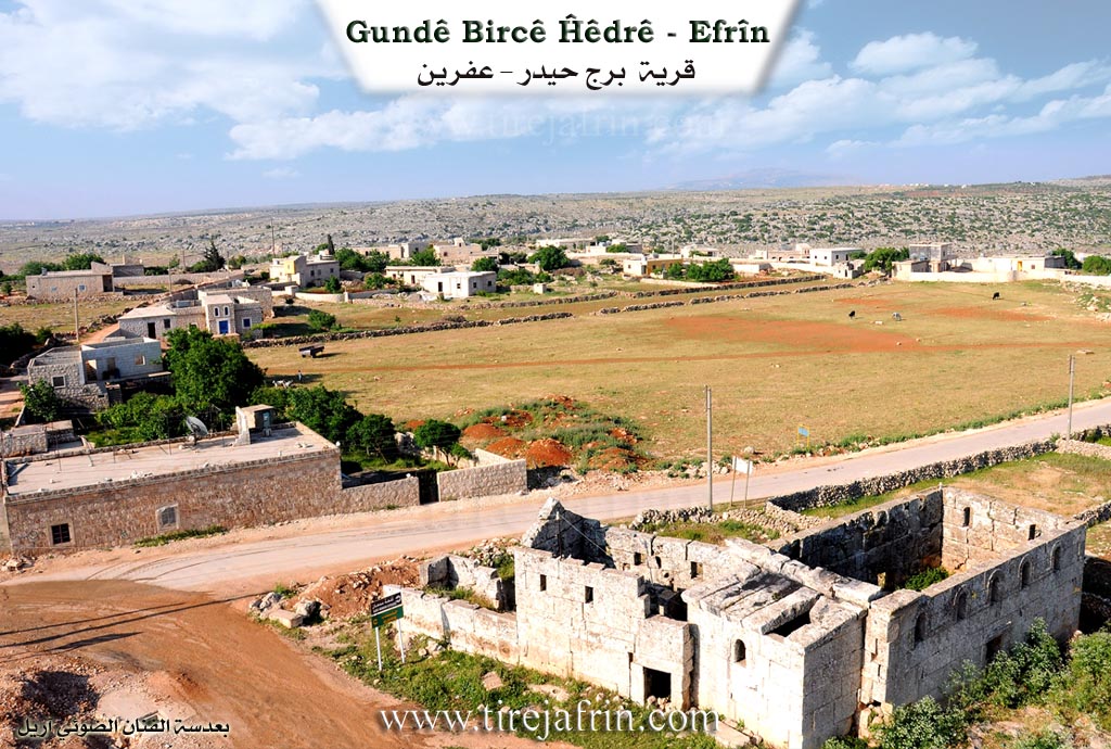
It is a large village among the villages of Şêrawa. It contains the remains of an old tower and a cathedral from the Byzantine era, with its walls and arches still standing, in addition to the presence of tombs, columns, and capitals. The residents have used some of its stones to build their houses.
It is stated in the book: عفرين .... نهرها وروابيها الخضراء Efrîn... Her River and Her Green Hills by the writer عبدالرحمن محمد Ebdulrehman Mihemed from the village of Qetme:
Burc Heyder: A village in Çiyayê Lîlon and Simean, belonging to the sub-district of the central villages, Efrîn region, Heleb governorate.
It is a large village located on the slope of a limestone plateau north of Wadiyê Rekiyê which heads southeast. To its south is another flood valley heading east. Its location is fortified and overlooks the surrounding area for a long distance. It is 25km southwest of Heleb.
Its settlement is old due to the presence of the remains of an old tower dating back to the Roman era and a cathedral from the Byzantine era, with its walls and arches still standing, along with tombs, columns, and capitals. The residents used its stones in building their houses.
It is bordered to the north by a rugged mountain range, a deep valley, and the archaeological village of Kefer Nabo close to it. To the south, it is bordered by a slope, a rugged mountain range of rocks, the village of Fafertîn, and Burc Silêman. To the east, a rugged mountain range and the village of Kebaşîn. To the west, a rugged mountain range and the village of Basûfan.
The number of its houses is about 100 houses, and the age of the village is about 500 years. The site of the village is very old due to the presence of ruins from the Roman and Byzantine eras and some columns and arches present in the center of the village.
Its dwellings are stone and mud with wooden roofs; some are built on top of ancient ruins, and the modern ones are reinforced concrete. An electricity grid is available, and the village drinks from a water network connected to a well dug south of the village of Zûqê Mezin located to its east. There is a primary school and a mosque.
The residents work in rainfed agriculture on an area of 194 hectares, and among its most important crops are grains, alongside the raising of sheep and cattle. An asphalt road connects it to the cities of Efrîn and Heleb.
Village Mukhtar: Ehmed Hesen
Preparation and execution:
Manager of Tirej Efrîn site: Ebdulrehman Hacî Osman
20/12/2013
Sources:
- Book: جبل الكرد (عفرين) دراسة جغرافية Çiyayê Kurmênc (Efrîn): A Geographical Study by د. محمد عبدو علي Dr. Mihemed Ebdo Elî.
- Book: عفرين .... نهرها وروابيها الخضراء Efrîn... Her River and Her Green Hills by عبدالرحمن محمد Ebdulrehman Mihemed from the village of Qetme.
II. Summary of Birc Ĥêderê from Ax û Welat
Source: https://www.youtube.com/watch?v=Nb-WkUCmel0
The village of Birc Heyder is located in the Şêrawa district of the Efrîn canton. The name of the settlement derives from two distinct sources. The first part, Birc, refers to the ancient ruins and towers scattered across the area. The second part honors a founding grandfather named Heyder.
Although the current families settled the area two or three centuries ago, the land holds a much older history. The village is home to ancient Roman and Greek ruins dating back 1700 years, with historical traces of the Hurrian and Mitanni civilizations. There are twenty ancient towers in the village that were historically used for surveillance and communication across the region. Additionally, the village contains twenty caves with ancient olive and grape presses, as well as five historic churches, including one referred to as Dêreşemsekî. Sun symbols etched into the ancient architecture represent Şeşşems, reflecting the historical presence of the Êzîdî faith.
The residents of the village belong to the Dinna tribe, a large kinship group primarily concentrated in the Sirûc plain of Turkey, particularly in a settlement called Aligol. Within Birc Heyder, the community consists of 120 to 150 houses, all descending from a single family lineage known as Gula Xêrê, tracing back to an ancestor named Elo yê Gula Xêrê. The villagers share deep kinship ties with the residents of Gundê Mezin, which later split into the villages of Birc Qasê and Kilotê. They also maintain familial connections with neighboring settlements such as Kibêşînya, Faqirtiya, Kîmar, Basûfan, and Xirabê Şemsê.
Before the first global war, during the Osmanî military campaign known locally as Seferberlik, the residents practiced the Êzîdî religion. To avoid intense persecution and military conscription, the villagers were forced to convert and adopt the Muslim faith, forever changing the spiritual landscape of the community.
Historically, the local economy relied heavily on agriculture and livestock. Villagers plowed their lands with oxen to cultivate wheat, barley, lentils, and fruits like apples and figs. They also tended large flocks of sheep and herds of cows. The community relied on a shared well called Rîk, located a kilometer away, which they used alongside the residents of Basûfan.
Women in the village were central to sustaining the local culture and household economy. They baked bread and festive sweets like kuleyçe and memûl in traditional tandoors. They also crafted intricate hand sewn garments, creating specific traditional embroidery patterns such as nêvka zerf, lîtik, henan, and gurçik. Traditional weddings in the village used to last an entire week, filled with communal feasts and henna ceremonies. Today, these celebrations are shorter, but families still bring brides from nearby villages, such as Başemrê near the Taxta mountain, preserving their vibrant cultural heritage.
Transcriptions and Subtitles
| Source | Video | Subtitles | Transcript |
|---|---|---|---|
| Ax û Welat 1 | Watch Video | Download SRT | View Transcript |
Possible Village Name Meaning of Birc Ĥêderê
The village derived its name from an archaeological tower that still stands in the village center, and from the name of its first inhabitant Haider. "Burj" is a word of Greek origin.
Source: TirejAfrin Site